9.9. Other Defined Terms
Abutting
Having a common border with or being separated from such a common border by a right-of-way, alley, or easement.
Access or Access Way
The place, means, or way by which pedestrians and vehicles shall have safe, adequate and usable ingress/egress to a property or use as required by this Code.
Accessory Use
A use conducted on the same lot as the principal use of the structure to which it is related and that is clearly incidental to and customarily found in connection with such principal use. Specific types of accessory uses are defined in Section 9.4.F, Accessory Uses.
Adjacent
The condition where two or more parcels share common property lines or where two parcels are separated only by an alley, easement, or street.
Affordable
The affordable housing unit is affordable to the specified target population when the monthly cost of homeownership or rent, including mortgage, property taxes, utilities and HOA fees or rent and utilities, does not exceed 35 percent of household gross monthly income.
Affordable Housing Development
A development that provides a sufficient number of affordable housing units to a target population that will remain affordable for a specified period of time.
Affordable Housing Unit (AHU)
The apartment, condominium, cooperative, townhouse, single-family, multifamily or manufactured housing unit that is made available to the target population for the period of affordability.
Applicant
A person who submits a development application requesting a development permit or approval authorized by this Code.
Architectural Feature
Any prominent or characteristic part of a building, including steps, eaves, cornices, awnings, chimneys, wing walls, windows, columns, marquee, façade or fascia.
Area Median Incomes (AMI)
The area median incomes for the portion of the two counties comprising the City of Sedona are determined by the United States Department of Housing and Urban Development and are updated yearly. AMIs are established for a range of household sizes, from one-person households to eight-person households. The current AMIs are available from the City of Sedona Department of Community Development.
Bedroom, Residential
Any habitable space in a dwelling unit or residential accessory structure where people may sleep.
Bee Colony
The hive and its equipment and appurtenances, including honey bees, comb, honey, pollen, and brood.
Beehive
A structure for housing honey bees.
Block
A piece or parcel of land or a group of lots entirely surrounded by public rights-of-way, streams, public lands, parks, and jurisdictional boundaries or any combination thereof.
Building
Building, Accessory
A subordinate building, attached or detached from the principal building.
Building, Attached
A building that has at least part of a wall in common with another building or that is connected to another building by a solid roof that exceeds six feet wide with opposite open ends.
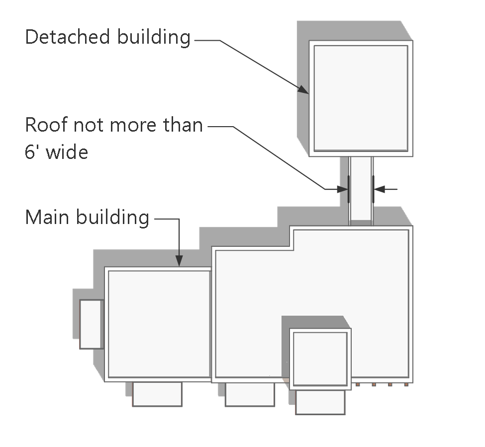
Building, Detached
A building that is separated from another building or buildings on the same lot, or that is connected only with a roof not more than six feet wide with opposite open ends.
Figure 9-6: Detached Building
Building Frontage
The side of a building that contains the main entrance for pedestrian ingress/egress. If more than one main entrance exists, the one that more nearly faces or is oriented to the street of highest classification, as determined by the City Engineer, shall be considered the building frontage. If all streets are of the same classification, the side of the building with the smallest linear dimension containing a main entrance shall be considered the building frontage.
Building Official
The municipal officer or agency charged with the responsibility of issuing construction and demolition permits and generally enforcing the provisions of the Building Code.
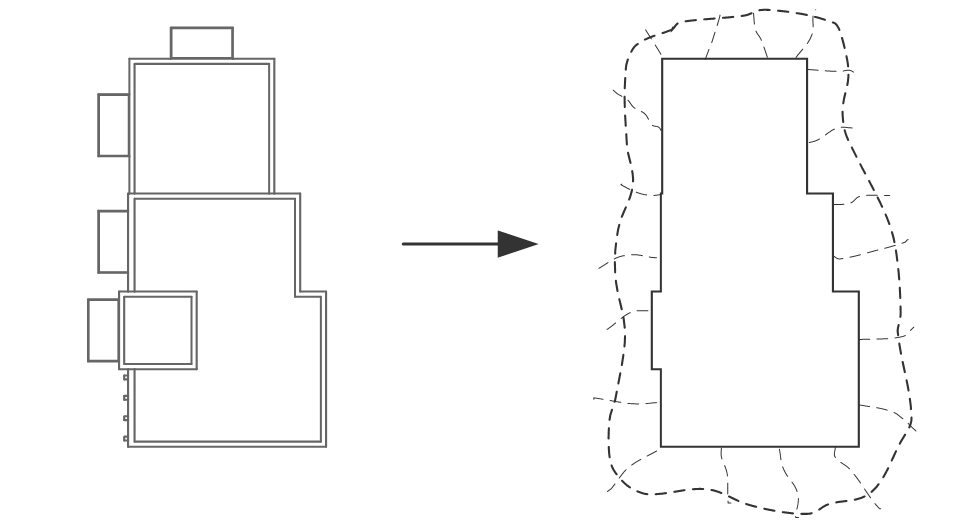
Building Pad
One or more specified areas of a lot or parcel prepared and graded for the erection of structures, or on which structures already exist.
Figure 9-7: Building Pad
Building, Principal
The building or buildings in which the principal use on a lot is conducted. In a residential district, any dwelling shall be considered the principal building of the lot on which the dwelling is situated.
Building Site
A legally created parcel or contiguous parcels of land in single or joint ownership which provide the area and the open space required by this Code, exclusive of all vehicular and pedestrian rights-of-way and all other easements that prohibit the surface use of the property by the owner. Private easements providing access to four or fewer parcels shall not be deducted from the building site area.
Cabana
A tent-like shelter, usually with an open side facing a swimming pool.
Certificate of Occupancy
A document issued by the Building Official pursuant to the Building Code that allows the occupancy and use of buildings and structures, certifying that such buildings, structures, and uses have been constructed and will be used in compliance with the Sedona City Code and this Code.
Code
The Sedona Land Development Code.
Conditional Use Permit
A type of approval issued pursuant to Section 8.4.B, Conditional Use Permit, for uses designated in the allowable use table (Table 3.1) as requiring conditional use permit approval.
Chroma
The strength, intensity, or brightness of a color. Strong chroma red is like the red in the United States flag, while a weak chroma red is like the darkest of the red rocks in Sedona. Weak chroma of any color is grayish or neutral, sometimes referred to as earth tones. The following degrees of chroma strength apply: very strong (Munsell 12), strong (Munsell 10), medium strong (Munsell 8), medium (Munsell 6), medium weak (Munsell 4), weak (Munsell 2), and very weak (Munsell 1).
City Engineer
The City Engineer and Director of Public Works.
Civic Event
Any type of race, parade, art show, competition, entertainment, or community activity to which the general public is invited, either expressly or by implication.
Cluster Subdivision
A subdivision technique and design that concentrates buildings in specific areas on a site to allow the remaining land to be used for recreation, common open space, and preservation of environmentally sensitive areas.
CMU
Concrete masonry unit.
Compaction
The densification to acceptable standards of a fill by mechanical means.
Construction
Any site preparation, assembly, erection, repair, alteration or similar action (excluding demolition) for or of public or private rights-of-way, sites, structures, utilities or other improvements.
Construction Envelope
One or more specified areas on a lot or parcel within which all structures, driveways, all grading, parking, nonnative landscaping, water surfaces, decks, walks and improved recreation facilities are located. Underground utilities may be located outside the construction envelope, but the area disturbed must be revegetated.
Contiguous
Having a property line, zoning boundary, or wall in common.
Culvert
A drain, ditch, or conduit, not incorporated in a closed system, that carries drainage water under a driveway, roadway, railroad, pedestrian walk, or public way, or other type of overhead structure.
Cut
The removal of earth material by excavation. “Cut” may also mean the grade resulting from the removal of earth material.
Dedication
An offer of real property by its owner(s) and its acceptance by the City for any general or public use.
Developer
Any person, firm, partnership, joint venture, limited liability company, association, or corporation who participates as owner, promoter, developer, or sales agent in the planning, platting, development, promotion, sale, or lease of a subdivision or development.
Development
The making of any material change in the use or appearance of any structure or land, the creation of a subdivision or the creation of two or three parcels pursuant to a minor land division over which the City has regulatory authority. “Development” includes such activities as the construction, reconstruction or alteration of the size or material change in the external appearance of a structure or land; trenching or grading; demolition of a structure or removal of vegetation; deposit of fill; or the alteration of a floodplain, bank or watercourse.
Development Plan Review
Review of development plans according to the procedures in Section 8.4.A, Development Review.
Development Project
Any development resulting from the approval of a building permit, minor land division, preliminary or final plat, rezoning application, or conditional use permit.
Director
The Director of the City of Sedona Community Development Department or his or her designee for the City pursuant to Article 8: Administration and Procedures. The Director is also the Zoning Administrator for the City.
Display Lot or Area
Outdoor areas where active nighttime sales activity occurs and where accurate color perception of merchandise by customers is required. To qualify as a display lot, one of the following specific uses shall occur: vehicle sales and leasing, equipment sales and rental, building materials and supply store, nursery or garden supply store, or assembly uses. Uses not on this list may be approved as display lot uses by the Director.
Drainage Way
See “watercourse.”
Driveway
A private access road, the use of which is limited to persons residing, employed or otherwise using or visiting the parcel in which it is located.
Dwelling Unit
One or more rooms with kitchen, living, and sanitary facilities for occupancy by a single family.
Easement
The portion of a lot or lots reserved for present or future use by a person or agency other than the legal fee owner(s) of the property. The easement may be for use under, on or above said lot or lots.
Erosion
The wearing away of the ground surface as a result of the movement of wind, water or ice.
Exception
A deviation from a required standard of this Code that does not require the obtainment of a minor modification or variance, and that is specifically authorized by the terms of this Code.
Exception (subdivisions)
Any parcel of land within the boundaries of the subdivision to be designated on the final plat as “not a part of this subdivision.”
Existing Lot
Lots or parcels zoned or legally used and legally created and existing on the effective date of the ordinance codified in this Code, including developed and undeveloped lots or parcels.
Façade
The exterior wall on the front, side, or rear elevation of the building regardless of whether the building side faces a street.
Family
Any one of the following:
(a) One or more persons related by blood, marriage or adoption, with or without minor children; or
(b) One or more unrelated persons with disabilities residing in a group home licensed by the state of Arizona. A group home must maintain a copy of its current state license at the dwelling unit available for inspection by the Director in order to qualify as a family pursuant to this definition. For purposes of this definition, a “family” may include a reasonable number of staff persons, who may or may not be domiciled with the family, providing support services, including but not limited to domestic, medical, or other similar services; or
(c) No more than a total of four unrelated adults with or without minor children, domiciled on a single residential lot.
Farm Animals
Animals other than household pets that may, where permitted, be kept and maintained for family food production, education, or recreation. Farm animals are limited to: Horses, mules, donkeys, cattle, alpacas, llamas, sheep, and goats.
Fill
A deposit of earth material placed by artificial means.
Floodplain
The total area required to pass the base flood through a natural watercourse, wash, canyon, ravine, arroyo or other potential flood hazard area.
Floodway
The channel of a river or other watercourse and the adjacent land areas that must be reserved in order to discharge the base flood without cumulatively increasing the water surface elevation more than one foot in height (as defined by FEMA).
Flyway Barrier
A solid wall, fence, dense vegetation, or combination of such materials, that is six feet in height and extends at least 10 feet beyond the beehive on each end of a bee colony.
Frontage
The width of a lot or parcel abutting a public right-of-way measured at the front property line.
Glare
The sensation produced by a bright source within the visual field that is sufficiently brighter than the level to which the eyes are adapted to cause annoyance, discomfort, or loss in visual performance and visibility; blinding light. The magnitude of glare depends on such factors as the size, position, brightness of the source, and on the brightness level to which the eyes are adapted.
Good-Faith Effort
What a reasonable person would determine is a diligent and honest effort to produce desired or required results under the same set of facts or circumstances.
Grade
The vertical location of the ground surface.
Grade, Existing
The current grade of a site.
Grade, Natural
The grade prior to manmade disturbance of a site.
Grade, Finished
The final grade of the site conforming to an approved plan.
Grading
Excavating, filling or combination of such operations.
Grading, Regular
Grading less than 1,000 cubic yards for single family residentially zoned parcels, or grading less than 250 cubic yards for multifamily and commercial zoned parcels.
Ground Cover, Nonvegetative
Rocks and small stones, cinders, granite, bark and natural red earth, not including pavement and concrete.
Ground Floor
The first floor of a building that is level to or slightly elevated above the sidewalk at the main entry, excluding basements and cellars.
Guestroom, Lodging
Any habitable room designed for overnight occupancy with a door to the exterior or common space.
Habitable Space
A space in a building for living, sleeping, eating or cooking. Bathrooms, toilet rooms, closets, halls, storage or utility spaces and similar areas are not considered habitable spaces.
Hillside Development Area
Any subdivision, portion of a subdivision, or any metes and bounds property within the City, located in terrain having an average slope exceeding 15 percent.
Horizontal Articulation
Breaking down a building façade into horizontal modules, sub-parts, or major elements that are distinguished by changes in materials, texture, plane, or other architectural elements.
Hue
The basic name or family of a color, such as red, orange, yellow, green, blue, or purple.
Inoperable Vehicle
A vehicle which exhibits one or more of the following conditions: physically incapable of operation, wrecked or partially dismantled or with broken windows, on jacks, blocks or similar equipment, abandoned, unable to be legally and safely operated, deflated tires, or from which the chassis, engine, wheels or tires have been removed.
Kitchen
A space where food is cooked or prepared and that contains facilities and equipment used in preparing and serving food, including, at minimum, a gas or electric range or oven, a kitchen sink, a refrigerator/freezer, kitchen cabinets, and an electric outlet for 220 voltage (and/or plumbing or standpipes capable of supporting such required equipment and facilities).
Kitchenette
A space where food is cooked or prepared that contains only a sink and a refrigerator, and does not include a gas connection, built-in stove, oven, any other built-in appliances, or an electric outlet for 220 voltage.
Land Division
The division of improved or unimproved land into two or three tracts or parcels for sale or lease with no new streets. “Land division” includes “land splits” as defined by Arizona Revised Statutes (as the division of improved or unimproved land of 2-1/2 acres or less for the purpose of sale or lease), and any division of a parcel of improved or unimproved land which is greater than 2-1/2 acres in size.
Land Surveyor
A person registered in the state of Arizona in the field of land surveying.
Landscape Architect
A professional individual registered in the state of Arizona to practice in the field of landscape architecture.
Light Reflectance Value
An expression (by percentage) of the lightness or darkness of a color equivalent to varying scale of grays. On a grayscale, an LRV value of 100 percent is equivalent to pure white (Munsell 10), and an LRV value of zero percent is equivalent to pure black (Munsell 0).
Lodging Density Rezoning
The procedure for any request to increase the number of lodging units in excess of the number allowed by right in a Lodging district or by an approved development agreement, pursuant to Section 8.6.A(2)d, Lodging Density Rezoning.
Maximum Extent Feasible
As determined by the Director, no feasible and prudent alternative exists, and all possible efforts to comply with the regulation or minimize potential harm or adverse impacts have been undertaken. Economic considerations may be taken into account but shall not be the overriding factor in determining “maximum extent feasible.”
Maximum Extent Practicable
As determined by the Director, under the circumstances, reasonable efforts have been undertaken to comply with the regulation, the costs of compliance clearly outweigh the potential benefits to the public or would unreasonably burden the proposed project, and reasonable steps have been undertaken to minimize any potential harm or adverse impacts resulting from noncompliance with the regulation.
Minor Modification
A development approval authorizing limited deviations from certain provisions of this Code’s dimensional or numerical development standards that is reviewed under Section 8.8.B, Minor Modification.
Motor Vehicle
Any and all self-propelled vehicles as defined in the Motor Vehicle Ordinance of the state of Arizona, including all on-highway motor vehicles subject to registration under that Code (excluding motorcycles), all off-highway type motor vehicles subject to identification under that Code, all enclosed motor vehicles with 3 wheels or more exempted under that Code and all other types of self-propelled vehicles with 3 wheels or more when used in any other manner.
Motorcycles
Any and all self-propelled two- and three-wheeled unenclosed vehicles as defined in the Motor Vehicle Ordinance of the state of Arizona and any self-propelled two- and three-wheeled vehicles with ground contact and equipped with a saddle for the use of the operator. This definition includes, but is not limited to, motor scooters, mini-bikes and off-road vehicles.
Munsell
Reference to the Munsell Book of Color, which is used to compare, evaluate, and classify paint and material colors. Munsell is a system that describes color in terms of three standardized attributes: hue (its basic color), value (its lightness or darkness), and chroma (intensity). Numerical values used in this Code define each attribute and the colors are arranged in the book in visual steps for each attribute.
Mural
An artistic design or representation painted or drawn on the exterior surface of a structure that is otherwise not defined as a sign.
MUTCD
Nonconforming Lot
A lawfully established lot created prior to adoption of this Code that does not comply with the minimum lot size requirements of this Code.
Nonconforming Sign
A lawfully established sign constructed or installed prior to adoption of this Code that does not comply with the sign regulations of this Code.
Nonconforming Site Feature
Any driveway, off-street parking and loading, landscaping, buffer, screening, or exterior lighting that lawfully existed prior to adoption of this Code but does not comply with the driveway, off-street parking and loading, landscaping, buffer, screening, or exterior lighting standards of this Code.
Nonconforming Structure
A lawfully established building or structure constructed or installed prior to adoption of this Code that does not comply with the area, height, or placement regulations of this Code.
Nonconforming Use
A use of land, or of a building or structure, that lawfully existed prior to the effective date of this Code that fails to comply with the requirements set forth in this Code applicable to the district in which the use is located.
Official Zoning Map
The City of Sedona Zoning Map, together with all data shown on the map.
On-Site Artworks
Public art provided on a subject development parcel.
Operable
For purposes of describing vehicles under this Code, an operable vehicle is one that holds all required licenses and insurance and is maintained in a roadworthy condition.
Parapet Wall
That part of any wall entirely above the roof line.
Parking Area
An area designed and constructed for the parking, storage and maneuvering of vehicles.
Parking Area, Covered
An area that is designed and constructed for the parking, storage and maneuvering of vehicles and that is covered by a roof; this definition includes garages and carports.
Parking Bay
A widened area designated for vehicular parking, including an area allowing for safe ingress and egress, and located parallel to a roadway off the designated travel way, but within the road right-of-way. A parking bay shall not extend for more than half a block or 50 feet, whichever is less. The ends of the parking bay are to be clearly delineated.
Parking Space
A space within a public or private parking area, exclusive of driveways, ramps, columns, offices and work areas, which is for the temporary parking or storage of one motor vehicle.
Pedestrian Way
A dedicated public walk or path.
Period of Affordability
The length of time an AHU must remain affordable to the target population.
Permeable Surface
An area of ground that, by reason of its physical characteristics and the characteristics of materials covering it, is able to absorb rain or surface water at a rate equal or greater than that of lawn turf. Examples include natural vegetation, landscape beds, gardens, mulch, decorative gravel, and some types of porous pavements.
Planned Development District
A development designed to accommodate varied types of development in patterns or layouts not otherwise permissible in other zoning districts established by this Code. Planned Development districts are designed to provide additional amenities or benefits to the City in return for flexibility in the design, layout, and dimensions of the development. Approval of a PD shall require a rezoning pursuant to Section 8.6.B, Rezoning to Planned Development District.
Planning and Zoning Commission
The Planning and Zoning Commission of the City of Sedona.
Plat
A map of a subdivision and associated required information which provides for changes in land use or ownership or which describes existing uses.
Plat, Conceptual
A design prepared for review and comment at a pre-application meeting and by the Commission. It is not a preliminary plat submittal.
Plat, Preliminary
A tentative plat, including supporting data, indicating a proposed subdivision design, prepared by a civil engineer, land surveyor, landscape architect, architect or land planner in accordance with these regulations and the statutes of the state of Arizona. A preliminary site plan for a condominium development shall be considered a preliminary plat.
Plat, Preliminary Revised
A plat reflecting revisions to the preliminary plat and the associated conditions of approval for review and comment by the Director before formal submittal of a final plat.
Plat, Final
A plat of all or part of a subdivision in substantial conformance with the revised preliminary plat, prepared by a civil engineer or a land surveyor in accordance with this Code and the statutes of the state of Arizona.
Plat, Recorded
A final plat, including all of the certificates of approval required by this Code, the statutes of the state of Arizona and recorded in the Yavapai or Coconino County Recorder’s Office.
Plat, Amended Final
A plat of all or part of a recorded subdivision proposing a change of design, lot lines, size of lots, number of lots, or street alignments.
Porch, Open
A deck, landing or balcony in which any portion extending into a front or side setback area shall have no enclosure by walls, screens, lattice or other material higher than 54 inches above the natural grade line adjacent to it. The porch is to be used solely for ingress and egress and not for occupancy.
Porous Pavement
Pavement, concrete, or pavers with a high permeability that allow rainwater to pass through it into the ground below.
Principal Use
The principal purpose for which land or a building is arranged, designed, intended, occupied, and maintained.
Professional Artist
An individual professionally trained in the arts and/or that receives compensation for works of art.
Private Access Way
A common driveway providing immediate access from a public right-of-way or private street to a residence or small group of residences or divided interests in air rights exempt from management, maintenance and liability responsibilities of the City.
Public Area
Any outdoor place to which the public or a substantial number of the public has access, including, but not limited to, rights-of-way, highways, transportation facilities, schools, places of amusement, parks, playgrounds and the outdoor common areas of public and private buildings and facilities.
Quasi-Judicial Hearing
A public hearing that is judicial-like in only applying the existing adopted regulations or policies to a specific development application, as opposed to the legislative-like creation of new laws or policies.
Regulatory Flood Elevation
One foot above the base flood elevation for a watercourse.
Religious Institution
A structure or place in which worship, ceremonies, rituals, and education pertaining to a particular system of beliefs are held, together with its accessory buildings and uses (including buildings used for educational and recreational activities), operated, maintained, and controlled under the direction of a religious group. Examples include churches, mosques, synagogues, and temples.
Revegetation
The reestablishment of native vegetation on previously disturbed land for the purpose of stabilization and the reestablishment of pre-disturbance conditions.
Revegetation Area
An area that has been disturbed by prior construction or development activity and that has had native plants and native rock material reintroduced.
Rezoning
A change in the zoning district classification applied to land by the Official Zoning Map, reviewed, and decided by the City Council under Section 8.6.A, Rezoning (Zoning Map Amendment).
Right-of-Way
Denotes an area of land property or interests usually located in a strip dedicated and accepted by the City or other entities, or otherwise required or devoted to uses such as highways, roads, streets, utilities, drainages, or pedestrian, bicycle, or equestrian ways.
Roof
The cover of any building intended to provide weather protection and design loads, including assembly components and the eaves and similar projections.
Roof Line
The highest point of a structure, including parapets, but not including spires, chimneys or heating or cooling mechanical devices.
Semi-Public Use
A use or building located on private land to serve public benefits.
Site Plan
A plan drawn to scale showing uses and structures proposed for a lot, including all associated submittal materials specified in this Code.
Slope
The vertical rise measured over a horizontal distance expressed as a percentage. A geographic information system (GIS) which uses TIN 3D modeling techniques is available at the Public Works or Information Technology Department and is recommended for use in calculating a slope analysis for any particular lot or parcel. The use of any other method of slope analysis shall be subject to review and approval by the City Engineer.
Soil
Naturally occurring surficial deposits overlaying bedrock.
Solar Equipment or Solar Energy Equipment (Rooftop and Ground-Mounted)
A photovoltaic power system designed to supply usable solar power by means of photovoltaics. Solar equipment is not considered a primary or accessory land use in the LDC and is, instead, considered mechanical equipment with required standard conditions of approval through the building permitting process. In residential zoning districts, solar equipment shall only be allowed on lots with an occupied dwelling unit.
Specified Anatomical Areas
Human genitals, pubic hair, vulva, mons veneris, anus, cleft of the buttocks, female breasts below the top of the areola or human male genitals in a discernibly turgid state, even if completely and opaquely covered.
Specified Sexual Activities
Actual or simulated sexual intercourse, masturbation, fellatio, cunnilingus, sodomy, flagellation, bestiality, fondling or touching of human genitals, pubic region, buttocks or the female breast, or any combination of the foregoing.
Spill
See “light trespass.”
Statutory Dedication
Dedication of land for open space, public rights-of-way, easements, utilities and the like required by Article 7: Subdivision, as a condition to acceptance of a subdivision plat for filing.
Stop-Work Order
An order issued by a City official that directs the person responsible for an activity in violation of this Code to cease and desist such activity.
Street
Any existing or proposed street, road, avenue, boulevard, land, parkway, place, bridge, viaduct or easement for public vehicular access or a street shown on a plat approved pursuant to law or a street on a plat filed and recorded in the County Recorder’s Office. A street includes all land within the street right-of-way, whether improved or unimproved, and includes such improvements as pavement, shoulders, curbs, gutters, sidewalks, drainage appurtenances, parking space, bridges and viaducts.
Street, Arterial
A street, as designated by the City Engineer, that provides through traffic with limited access to abutting properties and includes major streets or highways having regional continuity.
Street, Boundary (half-width street)
A half-width local or collector street, constructed with one edge coincident with a tract boundary which will be the future centerline of the street.
Street, Collector
A street that provides traffic movement between and within neighborhoods and between arterials and local streets and access to abutting property.
Street, Cul-De-Sac
A street having only one outlet for vehicular traffic, with a turnaround at the closed end which is not intended to be extended or continued to serve future subdivisions or provide access to other adjacent lands.
Street, Dead-End
A street open at one end only, without permanent provision for turning around, and that may be further extended into adjoining property.
Street, Local
A street that provides direct access to abutting property or for low volume local traffic movements and which connects to collector streets.
Street, Private
Any collector or local street in a recorded public easement in which the City reserves the right to install and maintain, or permit to be installed and maintained, utilities in the rights-of-way, including surface use for refuse collection, but which has been excluded from management, maintenance and liability by the City.
Structural Alteration
Any alteration to a structure involving a bearing wall, column, beam or girder, floor or ceiling joists, roof rafters, roof diaphragms, foundations, piles, retaining walls or similar components.
Structure
The result of arranging materials and parts together, such as buildings, tanks, and fences (but not including tents or vehicles) and placing them or attaching them to a lot. It shall also mean a mobile or manufactured home, anything constructed or erected, any edifice or building of any kind or any piece of work artificially built up or composed of parts joined together in some definite manner, which is located on or in the ground or is attached to something having a location on or in the ground, including swimming and wading pools and covered patios. Paved areas, walks, tennis courts, and similar outdoor areas and fences or walls three feet or less in height are excepted.
Subdivider
The individual, firm, corporation, partnership, association, syndication, trust or other legal entity that files the application and initiates proceedings for the subdivision of land in accordance with Article 7: Subdivision, and the regulations and statutes of the state. A person serving as agent for such legal entity is not a subdivider, and the subdivider need not be the owner of the property as defined by this regulation. The Council may prepare or have prepared a plat for the subdivision of land under municipal ownership.
Subdivision
Improved or unimproved land or lands divided for the purpose of financing, sale or lease, whether immediate or future, into four or more lots, tracts or parcels of land, or, if a new street is involved, any such property which is divided into two or more lots, tracts or parcels of land, or any such property, the boundaries of which have been fixed by a recorded plat, which is divided into more than two parts. “Subdivision” also includes any condominium, cooperative, community apartment, townhouse or similar project containing four or more parcels, in which an undivided interest in the land is coupled with the right of exclusive occupancy of any unit located on it. Plats of such projects need not show the buildings or the manner in which the buildings or air rights above the property shown on the plat are to be divided. “Subdivision” does not include the following:
(a) The sale or exchange of parcels of land to or between adjoining property owners if such sale or exchange does not create additional lots;
(b) The partitioning of land in accordance with other statutes regulating the partitioning of land held in common ownership;
(c) The leasing of apartments, offices, stores, or similar space within a building or trailer park, or mineral, oil or gas leases.
Subdivision Design
Street alignment, grades and widths; alignment and widths of easements and rights-of-way for drainage; sanitary sewers, public utilities, streets, roads, pedestrian ways; the arrangement and orientation of lots; locations of buildings; and provision for refuse collection and maintenance easements in condominium developments.
Target Populations
The households, including single-person households, whose incomes are at or below a specified AMI.
Trail
An access way or path, whether paved or unpaved, that is intended to serve multiple modes of nonmotorized travel.
Trailer
Any vehicle without motive power standing on wheels, designed to be towed or hauled by a private passenger motor vehicle or truck or other vehicle, and used for short-term human occupancy; carrying of materials, goods, or objects; or as a temporary office.
Tree
Any self-supporting, woody plant of a species which grows at maturity to an overall height of a minimum of 10 feet, has a single trunk or multiple trunks which are, in combination, four inches in diameter or has a circumference greater than 12 inches at a height of four and one-half feet above natural grade.
Turnarounds
Areas of sufficient alignment and dimensions as to allow fire trucks to turn around with no more than one backing movement required. The alignment and dimensions shall be subject to the approval of the Sedona Fire District and the City of Sedona City Engineer.
Turnout
A widened area designated as a no parking area, including an aisle for ingress and egress, located parallel to and immediately off the designated travel way, but within the road right-of-way. The ends of the turnout are to be clearly delineated. The turnout may be designed for use by emergency vehicles, such as fire trucks.
Unrelieved Building Plane
Any vertical surface, or the projection to a vertical plane of an inclined or curved surface, or wall of a structure that, when viewed in elevation, incorporates no overhangs, offsets, projections, decks, ramadas, loggias, or similar architectural features that would produce shadow patterns or otherwise serve to visually blend the structure into its natural background. Windows and doors do not in themselves provide relief, but if they project or recede a minimum of 12 inches they may be considered as providing visual relief.
Variance
The authorization by the Board of Adjustment for the use of land in a manner that is not allowed by the dimensional or physical requirements of the applicable regulations of this Code.
Vertical Articulation
Breaking down a building façade into vertical modules, sub-parts, or major elements, which are distinguished by changes in materials, texture, plane, or other architectural elements.
Visible
Capable of being seen, whether or not capable of being read, without visual aid by a person of normal acuity.
Watercourse
A creek, stream, brook, wash, arroyo, channel, or other topographic feature through which water flows intermittently or perennially. The term may include specifically designated areas in which substantial flood damage may occur.
Window
Any single window pane, or a series of adjacent window panes separated by a mullion(s) of 12 inches or less. Adjacent window panes set at different angles shall constitute separate windows regardless of the width of their mullion separation.
Zoning District
A classification established by this Code that limits or permits various and specific uses at specified lot and building standards.